Mapping Project titled “Recalibrating Queens”
Overview
Recalibrating Queens is a digital history and activist scholarship project focused on publicly excavating and exploring the past century of development and change in western Queens. This project is a direct response to recent and rapid changes, intensifying development pressures, and swelling community organizing, and was conceived alongside my resident-based organizing efforts with the Justice For All Coalition over the last 2+ years, and the development of my dissertation proposal as a student in the environmental psychology program at The Graduate Center, CUNY. It aims to provide another counterpoint for understanding contestations around development and change in a region that has undergone rapid change in recent decades, and to situate and elaborate residents’ experiences, perspectives and alternative visions for the development of their neighborhoods, which is central to my dissertation research.

Taken together, Recalibrating Queens is part of a larger goal to reexamine the past and resituate the present of western Queens so as to to reimagine a more just and community-centered future.
There are several components of this site that YOU might find useful in learning more about this project, or in your own organizing, educational and/or academic efforts. These are all accessible from the main menu bar at the top and the side-panel.
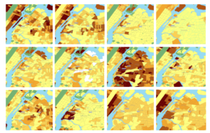
First, the centerpiece of the project right now is a series of maps which visualize changes in population and housing landscapes between 2000 and 2017.
Second, the data files undergirding these maps are accessible from this site. This includes the original CSV and shapefiles, as well as an new shapefiles and geoJSONs that were created along the way. These could be used to create your own map series or interactive, web-based map (see more below about the latter). Data was pulled for all 5 boroughs, so a very similar map series could be created for eastern Brooklyn, the south Bronx, and other regions of NYC – or for all of NYC entirely.
Third, the data sources from which the original data files were collected are shared. By back-tracking to the original sources, you could review the work completed here, or extend it by pulling additional data from these sources or pursuing other data sources and their data.
Fourth, I have been tracking different critical insights that have arisen for me in the context of this work. Again, these might be of interest to you in completing a similar project, or they may offer further insight into the work I am doing and my outlook on that work.
Fifth, I have created a community forum where visitors of the site can weigh on with their own interpretations of the maps, and insights from their own experiences. You may wish to contribute your own views, and/or review and respond to those of others.
Learn more: Recalibrating Queens
Posted on: September 17, 2019